01
Property boundary
Draw the parcel outline and label the available side lengths, bearings, street frontage, and lot area.
Site plan drawing for permits
A permit site plan is a scaled, top-down drawing of the property. It should let a reviewer see what exists, what you want to build, where it will sit, and which property facts still need verification.
Check my address freeFence, shed, and pool projects in Austin, Round Rock, Cedar Park, Georgetown, Pflugerville, and San Antonio.
The short answer
The permit office may ask for more, but these six parts make the property and project readable at a glance.
01
Draw the parcel outline and label the available side lengths, bearings, street frontage, and lot area.
02
Show the house, garage, accessory structures, driveway, and other improvements that affect placement.
03
Use a distinct line or hatch for the new fence, shed, or pool, then label its exact size and material where relevant.
04
Tie the proposal to property lines and nearby structures so a reviewer can understand where it sits without guessing.
05
Mark known easements, flood information, setbacks, or other mapped restrictions and state what still needs verification.
06
Add a north arrow, graphic and written scale, title block, project address, date, legend, and clear notes.
Three real examples
A fence is a line, a shed is a small footprint, and a pool brings its own review questions. Each still needs the lot, existing conditions, proposal, dimensions, orientation, and clear notes.
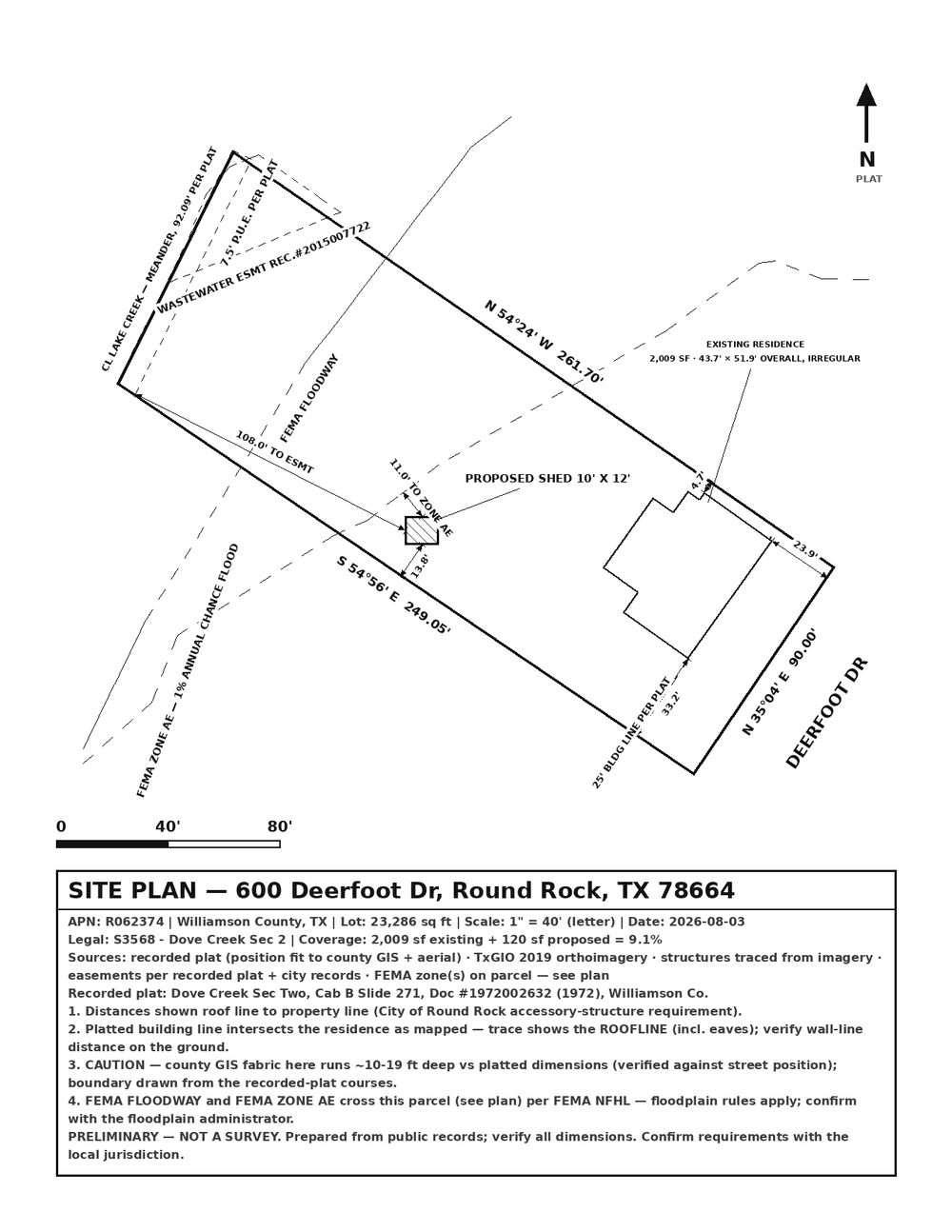
Fence drawing
This example labels the proposed six-foot cedar fence, total length, lot lines, structures, recorded easements, flood information, north, scale, and source cautions. The site also contains a proposed shed, so the reviewer can see both projects together.
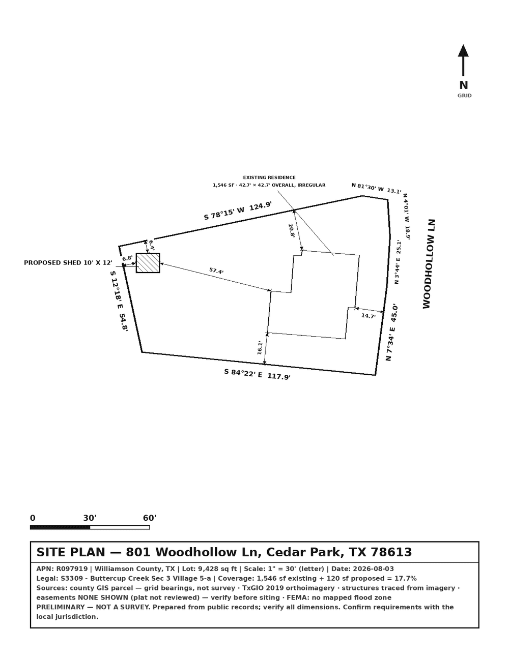
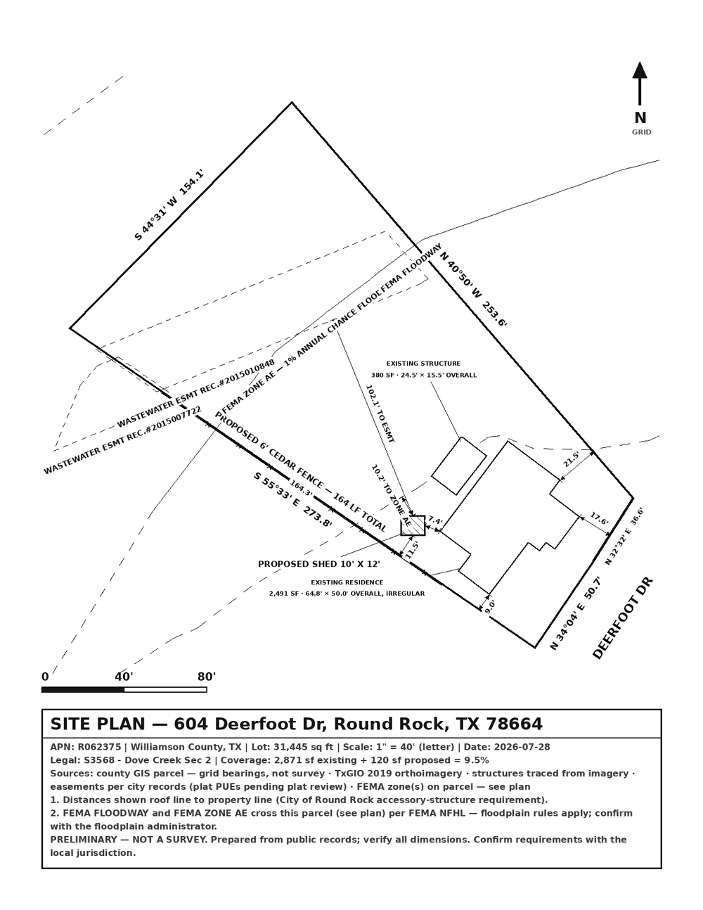
Shed drawing
The proposed 10-by-12-foot shed is hatched and labeled. Distances tie it to the side and rear property lines and the residence, while the title block states the parcel source, legal description, scale, and preliminary-plan boundary.
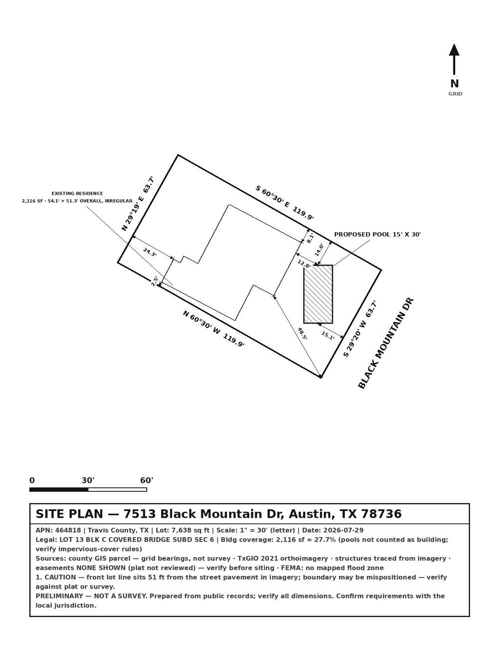
Pool drawing
The proposed 15-by-30-foot pool uses a clear hatch and dimension label. The sheet shows the surrounding lot, residence, street, nearest distances, scale, north arrow, and a caution where the public boundary source needs confirmation.
Seven drawing steps
Start with the reviewing office, not the drawing. Confirm whether it accepts an applicant-prepared plan and which project details it asks you to show. A fence application may ask for height and material. A pool application may add barriers, equipment, or impervious-cover information.
Collect a recorded plat or recent survey if available, county parcel information, the current project address, an aerial image, and your proposal dimensions. Treat public parcel and aerial data as starting material, not field-verified boundary evidence.
Fit the parcel on a readable sheet and state the scale, such as 1 inch equals 20 feet. Label the street and available lot dimensions. A scale bar gives the reviewer a second visual check if the page is printed or resized.
Trace the house, garage, driveway, sheds, pools, and other improvements that affect the proposal. Label existing versus proposed work plainly. If an outline comes from aerial imagery, inspect it and correct obvious offsets before relying on the distances.
Draw the fence run, shed footprint, or pool at its intended location. Add exact dimensions and the shortest useful distances to property lines and structures. Keep leaders and labels outside the geometry when possible so the plan stays legible.
Trace easements from the recorded plat when they are not available as mapped data. Add north, a legend, title block, source notes, and any caution the reviewer should see. Do not silently omit a constraint because its exact location is uncertain.
Compare the drawing with the permit checklist line by line. Verify the proposal size, address, scale, visible distances, and notes. Print or preview the final PDF at the size you plan to submit so small text and dimensions remain readable.
Choose the right route
A site plan communicates a project. A surveyor locates or certifies boundaries and other field conditions within a professional scope. They can look similar on the page without carrying the same authority.
Read the full site plan versus survey guide, or review the Texas Board of Professional Engineers and Land Surveyors' current surveying laws and rules.
Where EasySitePlan fits
EasySitePlan turns available parcel records and aerial imagery into an editable preliminary drawing. You inspect the lot, structures, proposal, dimensions, easements, and cautions before deciding whether the plan fits your permit.
Free preview, then $24
EasySitePlan does not certify boundaries, perform field measurements, provide engineering, submit the permit, replace every required document, or guarantee approval.
Compare the cost of self-service, drafting, and surveying, learn how to read a site plan scale, or review four ways to get a permit site plan.
Site plan drawing questions
Confirm the reviewing office's requirements, gather the best property records available, draw the lot to a stated scale, add existing structures, place and dimension the proposed work, mark known constraints, and check the finished sheet against the permit checklist. The drawing should make the project's location understandable without requiring the reviewer to infer distances.
A typical residential permit drawing includes the property boundary, street, existing structures, proposed work, relevant distances, known setbacks or easements, north arrow, scale, project address, date, legend, and notes. Exact requirements vary by project, address, and reviewing office.
Sometimes. Some reviewing offices accept applicant-prepared drawings for straightforward residential work. Others require more detail or professional work. Confirm the current checklist before drawing, and do not use a self-made plan when a boundary must be located, certified, or resolved.
The terms often overlap in residential permitting, but offices use them differently. Both commonly show the lot, structures, proposal, and distances. Use the name and content listed by the office reviewing your permit instead of relying on the label alone.
A recorded plat, recent survey, or reliable property documents can improve a preliminary drawing, but a site plan does not become a survey because it uses those sources. Hire a Texas registered professional land surveyor when a boundary must be located or certified, a line is uncertain or disputed, or a city, lender, title company, or project professional requires surveying work.
For an eligible fence, shed, or pool project in Austin, Round Rock, Cedar Park, Georgetown, Pflugerville, or San Antonio, EasySitePlan generates an editable preliminary plan from available public records and imagery. You inspect and correct the drawing, preview the watermarked sheet free, and can buy the clean PDF for a standard one-time price of $24.
No. The reviewing office decides whether the full application meets current requirements. EasySitePlan does not certify boundaries, provide engineering, replace every permit document, submit the permit, or guarantee approval.
Start with the property
The eligibility check, editor, local checklist, and watermarked preview are free. Pay $24 only when you want the clean PDF.
Check my address freeDrawing a fence plan for San Antonio? Check the local permit trigger, height limits, and filing requirements.
Want the public-record context? Read the July 2026 Texas permit activity note and its limits.